

Traffic and Mobility

Traffic and mobility management in Westmount aims to ensure safe, smooth, and harmonious travel for all road users. This section covers traffic calming policies, criteria for evaluating proposals, and municipal initiatives focused on road safety.
To report a situation concerning traffic, mobility or signage, use the online form on the Citizen Portal. If you have witnessed an infraction of the Highway Safety Code, your report must be sent to the Montreal Police (SPVM).
Maps and Documentation
Transportation Advisory Committee (TAC)
Role
The City of Westmount cares about the health and safety of its citizens, and is committed to maintaining the quality of life of its residents. The Transportation Advisory Committee (TAC) reviews requests from citizens, the administration or any other organization raising any needs or concerns regarding traffic and road signage.
Main Responsibilities
Any duly completed application, with respect to speeding, traffic, mitigation requests, shutdowns, markings or parking problems, will be analyzed according to a rigorous process and will be discussed by the TAC.
When required, the City may conduct studies and analysis, research solutions and coordinate projects, all in accordance with applicable laws, standards and policies.
Composition
The TAC is made up of elected City officials, City administrators and representatives from the Public Safety Department.
Important Information
The following guide was developed to facilitate and clarify the decisional process for all traffic and active transportation requests that are presented to the TAC. This includes, but is not limited to, the following complaints or requests:
- Speeding
- Increased vehicular volumes and through traffic
- Traffic calming measures
- Traffic lights
- Stop signs
- Signage and street marking
- Parking
This guide was developed based on the principles outlined in Westmount’s Traffic Calming Guide as well as in the Master Traffic and Active Transportation Plan. As per these plans, the objective of the TAC is to assess and evaluate each request and, where applicable, implement an appropriate and corrective measure. The benefits of such measures are not limited to simply managing speeds and reducing traffic volumes, but can include positive impacts on air pollution, noise and vibrations, accidents and pedestrian safety.
Traffic Requests and Complaints
Process for Submitting Requests and Complaints
The following process will be used to analyze all traffic related requests and complaints.
Requests
All requests are to be submitted in writing to the Transportation Advisory Committee (TAC) and must include the following information:
- Description of issue(s)
- Reason for the request
- Location of issue(s)
- Time when issue(s) occurs
- Name, address and contact information of submitter
The TAC may request additional information or conduct a site visit with the concerned stakeholders to better understand the problem.
In the event that a similar request was received, analyzed and closed by the TAC within the previous 24 months, the request will be reviewed to verify whether there has been a change in the site conditions or if the file pertains to a new safety concern. If there are no changes to report, the file will be closed and the requestor will be subsequently notified.
If you have witnessed a traffic violation and would like to file a witness report with the Service de police de la Ville de Montréal (police service, SPVM), please fill out a confidential observation report on the SPVM website.
Prioritisation
As numerous traffic requests and complaints are received, it is essential that each request be prioritised upon reception so that each file is analysed based on need rather than on a first-come, first-served basis. Therefore each request will be evaluated and rated according to the following criteria:
Priority 1: Safety
- Is there an immediate danger to pedestrians, cyclists or motorists?
- Is there a risk of injury or bodily harm?
Priority 2: Location of the problem
- Proximity to schools and school zones
- Parks and playgrounds
- Areas with a high concentration of pedestrians
- Bike paths
- Commercial areas
Priority 3: Impact on emergency services or City services
- Fire and ambulance access
- De-icing programmes
Priority 4: Other requests
Although all requests will be evaluated, special attention will be given to files classified as priority 1 or 2.
Identification of Applicable Policies
The relevant policies and the context will be identified for the sector under study to ensure that proposed solutions are coherent. All decisions should be consistent with other policies (Westmount Planning Programme, Westmount Traffic and Active Transportation Master Plan, traffic calming guide etc.). In addition, the street hierarchy, speed limit, fire routes, transit routes, cycling, corridors and school zones will all be identified.
Data Collection
The Public Works Department is responsible for all data collection. Data and studies will be considered valid for a period 24 months unless there is a significant change to the site conditions. Data will be collected between September 1 and May 31, and for a maximum of 5 days. This includes radar and speed assessment surveys, as well as traffic and volume counts.
Parking audits will be conducted a maximum of four times a day for five days over a period of two weeks.
Analysis and Identification of Issues
Relevant collected data will be analyzed by the City Administration. Any issue(s) will be identified, assessed and presented to the TAC. If the warrants outlined in the Evaluation and Analysis Parameters are not met, the file will be closed and will remain closed for a period of 24 months. If either one or more warrants are met, the process will continue. Meeting minutes will be kept during each Committee meeting and will be forwarded to City Council.
Identification and Evaluation of Measures
Effective and applicable measures (if any) will be identified to be considered by the TAC. Other measures from best practice guides may also be considered from time to time.
Analysis of various issues should take into account possible impacts on adjacent streets. Potential measures will be broadly evaluated before being discussed and presented to concerned residents.
Possible measures will be evaluated based on the following criteria:
- Effectiveness of measure to address identified issue(s)
- Impacts on adjacent streets (i.e. divert the problem onto another street)
- Impacts on on-street parking
- Potential to improve the streetscape
- Sustainability opportunities
Decision
The Committee will consider each request based on applicable policies, the analysis of the issue and other relevant information.
The Committee will then decide based on the criteria and considerations contained in the Evaluation and Analysis Parameters whether a measure(s) is warranted or not. The Committee will inform City Council (via meeting minutes) and concerned residents of its decision. Any recommended measures will then be forwarded for funding.
Any measure on a street scheduled for major roadwork in the next three years will be deferred and combined to this scheduled roadwork. The request will end at this point if it has not been approved by the Committee after residents have been informed.
If the TAC determines that immediate action is required for safety reasons, the Committee will proceed with the implementation of a mitigating measure without first polling the residents.
Resident Polling
Residents on a street block on which one or more traffic calming measure(s) or a change in parking is being considered will be polled. Concerned residents and property owners will be informed by mail or email and given sufficient time to respond. Any measure not supported by 75% of responding residents will not be considered by the Committee. A minimum threshold of 50% of households must vote for the poll results to be considered valid.
Implementation
The Public Works Department will be responsible for the design and implementation of approved measures. A temporary measure may be installed before it becomes permanent to assess effectiveness (if applicable) or if implementation is deferred.
Follow-Up and Evaluation
Following implementation, the City will evaluate if the measure or measures are effective. If necessary, modifications will be implemented accordingly.
Evaluation and Analysis Parameters
This section outlines the key elements used in the study and evaluation of various issues related to traffic management within the City:
| Request and/or nature of file | Criteria and warrants used for evaluation | Additional parameters to consider | Data collection |
|---|---|---|---|
|
|
|
|
|
|
|
|
|
|
|
|
|
|
|
|
|
|
|
|
|
|
|
|
|
|
|
|
The following parameters are also taken into account depending on the type of measures considered:
Resident Support
- The support of at least 75% of responding impacted households and property owners is necessary
Emergency Response
- Impacts on emergency vehicles cannot be significant. Emergency services will be consulted prior to implementing measures.
Operational Constraints
- Impacts on the City’s providing of essential services to residents cannot be significant (i.e. de-icing operations, snow clearing, etc.). Appropriate City staff will be consulted prior to implementing measures.
Transit
- The STM will be consulted when measures are proposed on street segments with transit service to determine the impacts.
- Street Grade Certain measures cannot be considered where grades are 8% or more
Hierarchy
- Certain measures cannot be considered on collector or arterial streets.
Mobility and Signage
Public Transportation
Bus
Metro
The Atwater, Vendôme, Villa-Maria, and Guy-Concordia metro stations also provide direct access to the outskirts of the city.
Paratransit
The STM paratransit programme offers door-to-door public transit service for people whose mobility is significantly impaired by a disability. To learn more about this service, visit the STM website or call 514 280-8211.
Bike Sharing
Road Line Painting
Each year, line painting on roads across the City are reviewed and refreshed as needed. Road line painting refers to vehicle and bicycle lane lines, as well as pedestrian crosswalks and other pavement markings.
When does line painting take place?
Road line painting takes place seasonally in the spring and early summer. Before any work begins, roads are surveyed to identify which markings have faded and require repainting. Not all lines are repainted every year, as some markings can remain visible and effective for several seasons depending on factors such as weather conditions and traffic volumes.
What kind of paint is used?
Different types of paint are used depending on the location and expected lifespan of the road marking:
- Water-based paint is a cost-effective option that dries quickly and is easier to apply. It is typically used on roads where construction or roadwork is planned in the near future, as the markings will eventually be removed as part of the project.
- Epoxy-based paint is more durable and can last for several years under favourable conditions. As such, it is more costly to install and requires specialised mixing and application. Its durability makes it well suited to heavily travelled roads and to climates with challenging weather conditions, such as those we experience in Canada.
How is the work planned?
Several factors determine when road line painting can take place. For the best results, markings should be applied to a clean, dry road surface and during periods when temperatures consistently remain above freezing. Road line painting is therefore coordinated with other seasonal activities, including street cleaning and other municipal work, and may be adjusted based on weather conditions.
Road line painting is generally carried out in the evening and overnight to ensure the safety of workers, motorists, cyclists, and pedestrians, while minimizing daytime traffic disruptions. Surface preparation work that is required ahead of marking operations may generate noise due to the use of pneumatic equipment. These nighttime noise disturbances are minimized whenever possible.
Priority markings including centre lines, pedestrian crossings, and stop lines are completed first, followed by secondary road markings.
Yield Street Signage
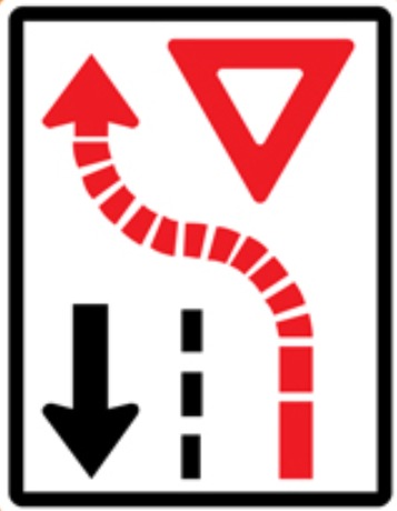
A yield street is a traffic-calming measure used on narrow, two-way roadways where space is insufficient for two vehicles to pass side by side comfortably. Instead of widening the road, one direction of travel is assigned priority. Vehicles traveling in the opposing direction must slow down, check for oncoming traffic, and yield the right-of-way when necessary.
Yield street sections are identified by official roadway signs:
Black arrow: Priority direction; vehicles may proceed with caution.
Red arrow: Yielding direction; vehicles must wait for oncoming traffic to clear before entering the narrowed section.
Benefits of Yield Streets
Yield streets prioritise community safety and urban livability over vehicle speed.
Enhanced pedestrian infrastructure: Maintaining a narrower road surface allows for expanded sidewalks, enhanced pedestrian safety, and additional streetscape landscaping.
Natural speed reduction: Narrowed lanes and yielding requirements prompt lower vehicle speeds and greater driver awareness.
Clear right-of-way rules: Establishing a designated priority direction eliminates driver hesitation on constrained streets, reducing potential traffic conflicts.
Improved incline management: Uphill traffic receives priority to maintain momentum, while downhill traffic—which naturally gains speed—must slow down and approach the narrowed area with caution.
Project: Safe Routes to School
The City of Westmount is continuing its efforts to improve road safety around schools in the City Hall area. This project aims to create safer school routes that are clearer and better suited to the needs of children, families and all road users.
The first measures of this project are scheduled to be implemented starting in July 2026, and will be rolled out gradually, with adjustments based on observations on the ground.