Personal information protection policy

This site uses cookies to optimize your browsing experience and track how you interact with it. By clicking on “I accept”, you consent to the use of these cookies. For more details on how we process this information, see our privacy policy.

I refuse

Where would you like to
share this page?

Menu
The URL address has been copied to your clipboard.

Parks and Green Spaces

Westmount’s network of parks and green spaces represents a true wealth of natural heritage, with 12 parks, 22 green spaces and one wooded nature reserve, the majority of which were established before 1940.

Despite its urban density, Westmount’s overall landscape and greenery owes much to its location on the western slope of Mount Royal and also to the presence – within its boundaries – of one of the three peaks of the Mount-Royal heritage site. In addition, the character of many of Westmount’s parks still reflects the city’s rich horticultural and sports traditions through its history.

Westmount also has a unique network of public staircases, which provide a passageway between certain streets and access to exceptional views.

The City of Westmount promotes a healthy lifestyle by encouraging its citizens to use their green spaces and public staircases as part of a health circuit and for other sports and leisure activities. We invite you to take the time to discover Westmount’s exceptional parks and unique green spaces.

Summit Woods

This natural urban forest and bird sanctuary occupies the western peak of Mount Royal and part of the protected area designated as the Mount Royal heritage site. The wooded lots, purchased by Sir William Macdonald in 1895, were donated to McGill University in the 1920s and bought by Westmount in 1940 under the site be preserved as a nature reserve in perpetuity.

At almost 2.5 million square feet or slightly more than 57 acres, this is Westmount’s largest green space. In this carefully preserved urban woodland, with pathways meandering throughout, wild birds and animals make this their haven, finding natural habitats in this tiny corner of the big city. Many wild plant and flower species also thrive in Summit Woods, and the City relies on you to help preserve this fragile area by refraining from picking or walking on the vegetation.

The north portion of Summit Circle between Summit Road and Oakland Ave. was closed to vehicles and the pavement removed. It was replaced with a pedestrian path, inaugurated in 2017. Cycling in Summit Woods is NOT PERMITTED.

Summit Woods remains a unique ecosystem and a peaceful place for walkers in the midst of a densely-built city.

Share

King George Park

Still called familiarly and affectionately by locals by its earlier name of Murray Park after William Murray, who sold a piece of his farmland to the City in the 1920s, King George Park was given its new moniker to mark the British Royal’s visit to Canada with his wife, Queen Elizabeth, in 1939.

At the northern limit of the park’s fourteen acre expanse is an immense playing field where lacrosse, Canada’s national sport, is played, along with rugby and soccer. In winter, the park is home to an outdoor rink for skating enthusiasts.

In the park’s central area are located a dog run, a tennis court area, a wading pool, a basketball net, as well as the comfort station, designed by internationally-celebrated Westmount architect, Robert Findlay. Findlay and his son Frank were commissioned by the City to design the pavilion in 1936, possibly as a make-work project during the Great Depression. The stone structure is classical in style, and houses changing rooms and washrooms. Mid-slope, a playground and a small pond area can be found on the east side.

Share

Westmount Park

At the recommendation of a citizens’ committee in 1890, the City acquired the grounds in 1898 to create Westmount Park. The Westmount Public Library and the Victoria Hall community centre were both inaugurated in its northwest corner the following year.

In 1912, M.J. Howard Manning undertook the landscaping for the City, laying out the park in the spirit of Frederick Law Olmsted – landscape architect for Mont Royal Park and New York’s Central Park – following the natural streams, ravines and wooded areas on the site.

Today, its 26 acres contain a wading pool, an extensive playground, beautiful floral plantings, playing fields and tennis courts. In the southwest corner of the park, a state-of-the-art sports complex, which includes two underground ice rinks and an outdoor pool, is partially concealed under a green roof.

Share

Devon Park

A park known as Westview occupied a portion of Devon Park as early as 1902 and the current layout was in place by 1949. Its rustic appearance, slopes and mature trees are in keeping with its location near the summit.

Share

Sunnyside Park and Summit Lookout

Acquired by the City in 1898, the construction and landscaping of the lookout, stairs and park were carried out in the 1930s. Summit Lookout offers striking views of Westmount, Montreal’s downtown area and the St-Lawrence River. At the foot of the Lookout, the stand of trees in Sunnyside Park could be said to be an extension of Summit Woods.

Share

Argyle Park

Argyle Park offers an oasis of greenery at the busy intersection of Westmount Avenue and The Boulevard. A result of the division of the Notman property, this tiny park first appeard in City records in 1898 and creates a harmonious urban ensemble with dwellings facing it.

Share

Prince Albert Park

This park, equipped with a playground, was built in 1927 and expanded in 1938. The comfort station was constructed in 1940. Its rectangular shape echoes the street pattern of the sector. An outdoor skating rink is maintained during the winter, and an accessible splash pad in the summer.

Share

City Hall Parl and Garden Point

This island of green, named Garden Point, first appeared on maps in 1902, the same year as the construction of the Lawn Bowling Club and greens. The City Hall building, by renowned architect Robert Findlay, was added in 1922, along with the nearby Cenotaph, designed by George Hill – a tribute to the sacrifice of Westmount citizens who died in battle during the First World War.

Share

Queen Elizabeth Gardens

Created on the former grounds of the Sulpicians, the harmonious composition of this green space  – a veritable little oasis in a densely-built area – includes a playground and winter skating rink.

Share

Westmount Athletic Grounds

Created by the Montreal Amateur Athletic Association (MAAA) in 1887, this space is Westmount’s oldest park. Purchased by the City in 1936, it featured a covered bleacher and many sporting grounds at that time. While its primary sports vocation has not changed, the WAG now includes a playground, tennis courts, community gardens and a dog park.

Share

Stayner Park

The east side of this park, built in 1924, was originally named Clandeboye prior to the addition in 1936 of the western portion. Today, Stayner Park includes a playground, a basketball court, a water play area, summer tennis courts and a winter ice rink.

Share

Bruce Tot Lot

This small alcove park was created in 1937 and was refurbished in 2001. It offers a shaded playground for the neighbourhood children.

Share

Somerville Tot Lot

This tiny pocket park was constructed in 1939 and re-landscaped in 1994 and also in 2001. Here, one can find a shaded playground area for the neighbourhood children.

Share

Westmount Bowling Greens

This green space was rented from Monk Estate in 1901 to establish a space for lawn bowling and the Westmount Lawn Bowling Club formally inaugurated the following year. The land was purchased by the City in 1920 and leased to the Club. The original pavilion was demolished in 1996 and replaced with an enlarged replica. Located on the north side of Sherbrooke St. at Kensington Ave., the bowling lawns provide a visually tranquil place next to a major traffic artery.

Share

Green Islands

These tiny vegetated spaces, located around the City, reflect the horticultural traditions of Westmount, as well as the 20th-century ‘garden suburb’ movement. These pockets of greenery harmonize with the hilly landscape and with the residential character of Westmount’s neighbourhoods. They include:

  • Surrey Gardens (boulevard islands)
  • Clarke Island (at the north end of Clarke Ave.)
  • NDG-Claremont Island
  • Forden Islands (2) between Montrose and Westmount Aves.
  • Dorchester and Clarke Islands (east and west of the intersection)
  • Weredale Island
  • Prospect St. green space
  • Lansdowne-Ste-Catherine green space (n-e of the intersection)
  • Glen-Ste-Catherine green space (s-w of the intersection)
  • York-Ste-Catherine green space
Share

Public Stairs and Ramps

Given its sloping landscape, Westmount has a number of green corridors and public staircases, which provide shortcuts to some streets, as well as access to impressive views of the City and the St. Lawrence River. Many of these tiny green spaces date back to the early 20th century. They include:

  • Sunnyside steps (at Summit Lookout)
  • Roslyn Stairs (north of The Boulevard)
  • The Boulevard-ch. Edgehill-rue Summit Circle Stairs (north of Renfrew Ave.)
  • Bellevue-Sunnyside Stairs (from the north end of Aberdeen Ave.)
  • Mount Pleasant Slope (between Holton and St-Sulpice)
  • Thornhill Stairs (from the north end of Stanton St.)
  • Belmont Crescent (near Côte-St-Antoine and Lansdowne)
Share

More information

Accessibility

Westmount’s parks are designed to provide access to persons with reduced mobility through wide paved pathways, accessible washrooms, a sufficient number of benches and adequate lighting.

The City has installed ADA-standard adapted swings in most playgrounds.

More information

Share

Wild Animals

It is forbidden to feed animals on public property in Westmount.

More information

Share

BBQs

The use of BBQs is prohibited in Westmount’s public parks and green spaces.

Share

Dogs

Dogs must be leashed at all times, except in designated dog parks. Use the button below to find out about Westmount’s dog parks, dog regulations and how to obtain a dog permit.

More information

Share

Curfew

All parks in Westmount are closed to the public nightly between midnight and 5 a.m. (By-law 69).

Due to a dramatic increase in reports of vandalism, graffiti and substance abuse infractions in municipal parks, the City of Westmount adopted curfew in all parks in June 2007. Parks in Westmount are closed to the public nightly from 12 a.m. to 5 a.m.The curfew regulations are included in By-law 1350, an amendment to By-law 69 concerning parks.

Violators will be subject to a minimum fine of $75 plus costs for a first offence and a fine of $300 plus costs for a second or subsequent infraction.

Share

Events

As a densly-built and primarily residential community, Westmount recognizes the importance of maintaining its green spaces open and accessible to the public at all times.

Private events that require the reservation of any parts of a park or the delineation of an exclusive area within a park are not permitted. Westmount residents and community groups may request the use of a green space for certain events, however. Use the button below to consult the City’s policy and the guidelines for using a park for an event.

Policy on the use of parks for events

Share

Smoking Ban

All smoking, including the use of electronic cigarettes, is prohibited in Westmount’s parks and green spaces. New restrictions came into force on September 8, 2018.

More information

Share

Invasive Plants

Identify and limit the presence of invasive plants in Westmount

Invasive plants are non-native trees, shrubs, grasses and flowers that have been spread by human activity, intentionally or accidentally. They are often capable of reproducing and spreading rapidly, outcompeting native species and upsetting the ecosystem balance. According to the International Union for the Conservation of Nature (IUCN), invasive alien species are the second most significant threat to biodiversity after habitat destruction.

In their new ecosystems, invasive alien species can become predators, competitors, parasites, hybridizers, and diseases of native and domesticated plants and animals. The impact of these alien species on native ecosystems, habitats and species is severe and often irreversible.

Prevention is key to controlling the spread of invasive plants. Keep reading to learn more about preventing and controlling common ragweed and Japanese knotweed, an exotic invader that has been identified in Westmount.

Sources: Environment and Natural Resources (Canada), Ministère des Forêts, de la Faune et des Parcs (Québec)

Common Ragweed
(Ambrosia artemisiifolia)

Common ragweed — an invasive annual plant found throughout Quebec — is considered to be the main cause of allergic rhinitis or hay fever. More than 10% of the population is affected by the light, airborne pollen, which may cause sneezing, irritated nose and eyes, coughing and asthma. A single ragweed plant is capable of producing several million grains of pollen during its flowering stage from mid-July until the first frost.

IDENTIFY
Ragweed, which can reach up to 2m high, is recognizable by its serrated leaves and spiked flowers. Its appearance varies with its stages of growth. It tends to grow in poor, arid and disturbed soils, and is frequently seen along roads, streets and sidewalks, as well as on industrial land.

REMOVE
Ragweed is easy to pull up, especially in the early stages of growth. When there is too much to remove by hand, mowing will help prevent or delay the flowering stage.

DISCOURAGE FLOWERING
Ragweed will not produce pollen if the plant is uprooted or cut before the flowering stage. Repeated mowing is necessary, however, to prevent the flowers from developing.

PREVENT PROPAGATION
Ragweed is often found in difficult growing conditions. It does not compete well with other plants in fertile soil, including grass. By keeping your lawn and garden healthy, ragweed is less likely to find a niche.

Read more about ragweed

Japanese Knotweed
(Reynoutria japonica or Fallopia japonica)

Japanese knotweed is an aggressive semi-woody perennial plant that is native to eastern Asia. It was introduced to North America in the 19th century as an easy-to-grow ornamental and was also planted on shorelines to prevent erosion because of its strong root system.

Now illegal to sell or propagate, the plant is very rarely seen in stores, but has been found under the label ‘Japanese Bamboo’. The IUCN has listed it among the 100 worst invasive species in the world.

Although Japanese knotweed was once mostly found along road ways, ditches and along waterways, its past commercial popularity and aggressive root system means that it can now be found anywhere. Knotweed and other exotic invasive species often favour bare areas where there are little to no native species to compete with.

AVOID
Do not buy, plant or walk through Japanese knotweed or any plant that may resemble it. This invader is very persistent due to the lack of natural predators, its ability to spread aggressively from the smallest fragment, and its resistance to Canadian winters. Once established, it is extremely difficult to control. The plant re-roots extremely easily and even the tiniest fragment will grow into a large plant. It is important to avoid disturbing these plants as unintentional propagation may occur. In wooded areas, always stay on pathways and never take cuttings for home or the cottage.

IDENTIFY
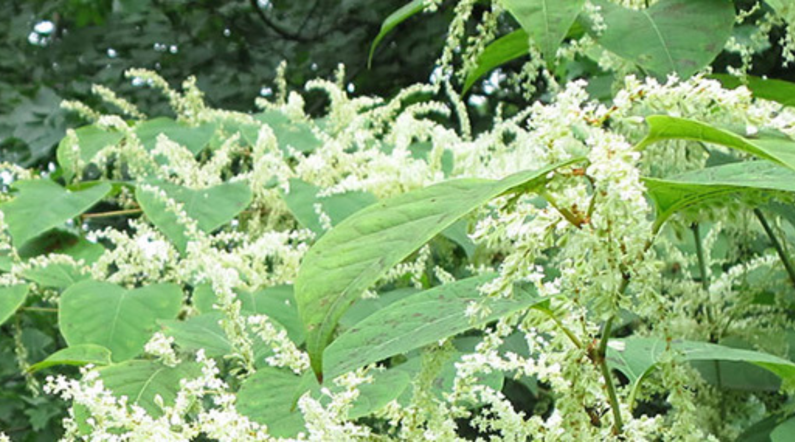
Japanese knotweed is often mistaken for bamboo because of its appearance: large oval/heart shaped leaves (3-6 inches long and 2-5 inches wide), round reddish-purple hollow stems with bamboo-like knots, very rapid growth reaching 1-3 metres in height, small greenish-white flowers that produce a small white fruit with wings that disperses seeds efficiently, and brown shiny seeds.

ASSESS THE GROWING ENVIRONMENT
Before deciding on a removal method, consider the site conditions first to ensure the best results. In full-sun areas: cut the plants and solarize (cover with a dark tarp), and re-seed the area with native plant seeds adapted to full-sun. In shaded areas: do repeated cutting without solarization (the heat produced will not be sufficient to cook the roots effectively), and re-seed the area with native plant seeds adapted to full shade. Repeatedly cutting knotweed low to the ground from April until October will stress the plant and its root system. This constant stress and absence of leaves to absorb nutrients will eventually result in the death of the plant.

PREVENT PROPAGATION
Japanese knotweed spreads aggressively through an extensive rhizome network (horizontal plant stems growing underground). Stem growth is renewed each year from this deep underground system and its growth is rigorous. Once established, the root system is almost impossible to remove, as it can spread as deep as 10 feet beneath the surface.

  • Cut all Japanese knotweed plants as low to the ground as possible and never allow it to grow over 1 foot in height or to go into flower or seed. 
  • Pay special attention to cut any small satellite plants growing away from the main concentration. 
  • Never mow or roto-till Japanese knotweed as this creates small fragments which may re-root and create many new plants. 
  • Always check machinery and clothing for plant fragments to avoid spreading the weed.

ERADICATE THE PLANT
The best way to eradicate Japanese Knotweed is to starve the plant of sunlight and energy by repeatedly cutting all shoots at the ground, as outlined above. Focusing on smaller new growth in priority will deter these new plants from growing bigger and stronger. Re-planting the area with native vegetation once control measures are complete will help to suppress re-sprouting and assist in preventing new invaders from establishing.

DISPOSE OF ALL PARTS OF THE PLANT CAREFULLY
Knotweed and its fragments should never be placed in the compost. Always double bag any part of the plant and place in the garbage.

  • Always dispose of knotweed (leaves, flowers, stems or root fragments) in double garbage bags in the regular garbage collection. 
  • Never dispose of any part of the plant in compost (residential or municipal). 
  • Even small fragments of the plant will re-root and can often survive commercial processing of compost. Dispose of any soil removed during these types of interventions also; it is contaminated and cannot be used elsewhere to avoid propagating the plant
Share

Urban Forest

Westmount's Urban Forest: Your guide to the City's programme to protect and improve our green infrastructure.

Trees – a collective heritage

Trees are an important part of Westmount’s character and history. From the time of the Iroquois, to the arrival of the French and British, to the present, the local landscape has been defined by its patchwork of charming paths and roads winding through the forested western slope of Mount Royal.

The word forest isn’t reserved only for expanses of trees in remote areas. An urban forest – sometimes called green infrastructure – is defined as all of the trees and other vegetation within a built-up area, both public and private. In a sea of grey infrastructure, trees represent a vital bridge between city dwellers and the natural world.

Originally composed of maples, birches, and elms, the local forest changed with the arrival of European settlers, who gradually introduced orchard trees and ornamentals, and later, some hardy species well suited to the rigours of an increasingly urban environment.

Westmount’s urban forest

Many of the trees in the City have an extensive history. As part of our shared heritage, these trees are treasures to preserve, particularly in today’s urban environment. All measures are taken to protect and care for these historic trees for as long as possible.

In addition to its management of public trees, Westmount encourages the planting of trees on private property. Each spring, it offers a limited number of young ornamental or fruit trees at no charge for residents that wish to plant them on their property.

Westmount’s contemporary urban forest, like many other North American cities, is composed primarily of Norway maple (Acer platanoides) varieties, many of them planted in the mid-20th century as a sturdy, fast-growing replacement for the rapid loss of American elms to Dutch elm disease.

Managing the Urban Forest

The City is committed to the development of a proactive forest management strategy. Thanks to new technologies, leading-edge arboricultural practices, and science-based decision-making, Westmount’s urban forest is becoming healthier, safer, and more biologically diverse.

By planting ecologically-appropriate tree cultivars – the right tree in the right place – and by using best management practices (BMP), the City will ensure a vibrant urban forest for future generations.

Why tree removal is necessary

Westmount is committed to the ongoing observation, evaluation, and maintenance of its trees, replacing them when necessary to ensure a robust, abundant and biologically-diverse forest throughout its territory.

The typical life expectancy of an urban tree is 60 years. The majority of Westmount’s Norway maples, estimated to be between 60 to 80 years of age, are likely now in decline and many will reach the end of their lifespan within a short period. Pruning, cabling, and other maintenance techniques are used where appropriate to prolong the life of trees and ensure public safety. In many cases, however, felling is a better option to improve the biological and age diversity of the forest.

Benefits of Trees in Our City

Urban forests provide crucial ecosystem services such as improved mental and physical health, improved air, water and soil quality, stormwater management, wildlife habitat, shade, and a reduction in the heat-island effect.

An aesthically-pleasing abundance of trees also provides economic value, contributing to higher property values and more successful business districts.

Urban Forest Intervention

Evaluating the health of a tree is not a simple process; it involves specialized equipment and professional expertise. It may result in the detection of structural problems or a diagnosis of a disease that reduces the tree’s vigour and negatively impacts the growth of other trees around it. In recent years, the Emerald Ash Borer (Agrilus planipennis), an invasive beetle from Asia, has killed Ash trees, causing immense damage to wild and urban forests in the northeast part of the continent.

Cycle of the Urban Forest

Share

Private Tree Removal

Pests & Disease of the Urban Forest: Emerald Ash Borer

Emerald Ash Borer

Emerald Ash Borer (Agrilus Planipennis)

The Emerald Ash Borer (EAB) is a highly destructive insect pest of ash trees. Native to eastern Asia, this pest was first discovered in Canada and the U.S. in 2002. The EAB has killed millions of ash trees in Southwestern Ontario, Michigan and surrounding states, and poses a major economic and environmental threat to urban and forested areas in both countries. The EAB attacks and kills all species of ash (except Mountain ash which is not a true ash).

How does the EAB spread?

While the EAB can fly up to several kilometres, another significant factor contributing to its spread is the movement of firewood, nursery stock, trees, logs, lumber, wood with bark attached and wood or bark chips.

Signs of infestation

Tree decline, including:

  • thinning crown
  • diminished density of leaves
  • evidence of adult beetle feeding on leaves
  • long shoots growing from the trunk or branchesvertical cracks in the trunk
  • small D-shaped emergence holes
  • S-shaped tunnels under the bark filled with fine sawdust

Preventive Measures

Montreal’s major project (french only)

“The project, led by the Service de l’environnement of Montréal, consists in releasing natural enemies of the emerald ash borer (EAB). Several thousand parasitoids will be released at different times during the summer in some natural woodlots, such as Westmount’s Summit Woods Green Space. This classical biological control project, through the use of exotic natural enemies of the EAB, is a long-term strategy for the conservation of natural woodlots in urban areas.”

Westmount statement: Biological control

Don’t move firewood

Transporting firewood can destroy millions of trees

Invasive insects and diseases can live in cut wood. Moving untreated firewood, even just a few kilometres to or from a campground or a cottage, is a common way for invasive insects and diseases to spread.

Share
Pests & Disease of the Urban Forest: Emerald Ash Borer

Forest Tent Caterpillar

Forest Tent Caterpillar (Malacosoma disstria)

Behaviour

The Forest Tent Caterpillar is an insect native to North America that is widely found throughout the continent. In fact, it is one of the best known defoliating insects.

The Forest Tent Caterpillar breeds only once a year. The first caterpillars appear in early May, when the leaves of the aspen tree, its preferred host, are spread out. From the time they appear until they reach maturity, around mid-June, they greedily devour the tender foliage. During this time, they undergo five larval moults.

Hosts and damage

In Canada, the Forest Tent Caterpillar has been observed on 29 different species, including 27 types of hardwoods. However, its preferred hosts remain, in decreasing order, aspen, white birch, sugar maple, willows and red oak. The red maple does not attract it at all.

Forest Tent Caterpillars can occasionally severely, if not completely, defoliate their hosts over large areas.

Intervention and Control

A variety of treatments can be used to protect ornamental trees, such as spraying with water containing dishwashing detergent (1 tsp. per liter). The biological insecticide, Bacillus thuringiensis (B.t.), sold under various brand names, is also effective against forest tent caterpillar. The insect that ingests it dies a few days later. B.t. must therefore be applied very early in the spring, as soon as the foliage has reached its maximum size, to ensure that the insecticide is deposited on an adequate surface. In high value stands, B.t. can be applied if the egg population survey in the fall indicates that significant damage will occur the following spring.

For more information, go to the Ministry of Natural Resources and Forestry of Ontario.

Share

List of Suitable Trees and Public Trees Map

Comments associated with a public tree

The Public Works Department intervenes only on public trees. If you cannot find the tree on the map, please include your address in the message field. 

Please note: If you request an evaluation for work on trees near power lines, please contact Hydro Westmount Customer Service at 514 925-1414.

Tree inspection form

The site number can be found on the above map; it is attributed to a given point on the map. Each point represents a tree, stump, or planting space.

0 of 200 max characters.