
Maps and Landmarks

Discover Westmount through interactive maps.
Westmount is a residential enclave on the island of Montreal in Quebec, Canada. It lies within walking distance of Montreal’s downtown core, yet retains an air of tranquility and small-town community.
The City's map portal features views of Westmount from a variety of perspectives. Explore the City's landmarks, discover the electoral districts, travel over the urban forest, and much more.
Reference Maps
Waste Collection Map
Consult the Waste Collection Map to view collection schedules by sector and to identify which lanes are not accessible to collection trucks. Note that the waste collection sectors are not the same as the Westmount electoral districts.
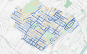
Traffic and Signage Map

This map contributes to a better understanding of traffic flows. Get an overview of parking regulations, truck traffic routes, school zones and the bicycle network.
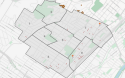
Electoral Districts Map
Each of Westmount's eight electoral districts is represented on City Council by a councillor elected from the community.
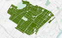
Urban Forest Map
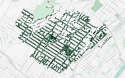
Trees are an important part of Westmount’s character and history. From the time of the Iroquois, to the arrival of the French and British, to the present, the local landscape has been defined by its patchwork of charming paths and roads winding through the forested western slope of Mount Royal.
The map of Westmount's urban forest identifies all trees on the public domain, excluding Summit Woods, and their species.
Landmarks Map
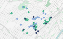
The heritage and tradition of the City of Westmount is nowhere more visible than in its buildings, floral designs and monuments. Each landmark serves to illustrate the City’s strong links to its past, and signal the continuing desire to foster its own distinct residential character. Across Westmount, you’ll find century-old buildings in constant use, maintained by dedicated staffs that spare no expense in preserving our unique heritage.
Accessibility Map
Find the locations of accessible public parking, parcs with accessible play structures and accessible municipal buildings.
Mobility and Transit Map
The City encourages residents to adopt active and sustainable means of transportation. Plan your urban trips with the help of this map, which shows the location of bus stops, bike-sharing and car-sharing stations, and electric vehicle charging stations in Westmount.
Looking for bike paths? Refer to the Traffic and Signage map.
Power Outages Map
See the map of power outages in the Hydro Westmount network in real time.
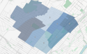
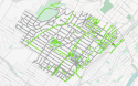
Zoning and Character Areas Map
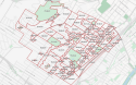
The City of Westmount is subdivided into 39 character areas which all have their distinctive features. Each property can be located on the maps. A list of buildings and their respective heritage value (by category) is compiled for each area.
Roadwork and Construction Map
Consult ongoing roadwork and public construction projects in the City.
Project Maps
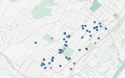
LED Lighting Map
In order to improve the energy efficiency of its urban lighting, the City of Westmount is replacing the bulbs in its public lighting fixtures with LED (Light Emitting Diode) bulbs. This transition is part of a sustainable development approach that allows the City to maintain it's existing light fixtures, particularly the Washington-style street lamps.
View the progress of the project via the map, and obtain information on the characteristics and energy savings of each lamp.
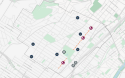
Map of Horticultural Interventions at King George Park
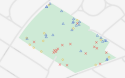
Many of the trees at King George Park have exceeded their natural life span and have been irreversibly damaged by invasive insects. The City is pursuing a multi-year action plan to secure and ensure the long-term survival of its forest heritage through tree felling, securing and planting at King George Park.
Consult the map to learn about the planned interventions for the current phase of the project.
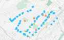
Lead Services Replacement Map
Replacing water services containing lead on public land is a core element of the City's Action Plan for the elimination of lead in drinking water. Since 2007, the City of Westmount has been actively replacing lead services through the annual capital works programme as well as through the Public Works’ annual water maintenance programme.
This map visually represents upcoming projects and previous interventions to replace lead services in Westmount.